-
Paper Information
- Next Paper
- Previous Paper
- Paper Submission
-
Journal Information
- About This Journal
- Editorial Board
- Current Issue
- Archive
- Author Guidelines
- Contact Us
Journal of Civil Engineering Research
p-ISSN: 2163-2316 e-ISSN: 2163-2340
2014; 4(3A): 54-58
doi:10.5923/c.jce.201402.08
Landslides Hazard Map in Malay Peninsula by Using Historical Landslide Database and Related Information
 Abstract
 Reference
 Full-Text PDF
 Full-text HTML
Satoshi Murakami1, Tay Lea Tien2, Rohayu Bte Che Omar3, Tomomi Nishigaya1, Nazirah Aziza4, R. Roslan3, I. N. Z. Baharuddin3, Habibah Hj Lateh4, Naoki Sakai5
1Urban & Civil Engineering, Ibaraki University, Japan
2School of Electrical and Electronic Engineering, Universiti Sains Malaysia, Malaysia
3Civil Engineering, Universiti Tenaga Nasional, Malaysia
4School of Distance Education, Universiti Sains Malaysia, Malaysia
5National Research Institute for Earth Science and Disaster Prevention, Japan
Correspondence to: Satoshi Murakami, Urban & Civil Engineering, Ibaraki University, Japan.
| Email: |  |
Copyright © 2014 Scientific & Academic Publishing. All Rights Reserved.
Recently, slope disaster has occurred in regions around urban area and along highways in Malay Peninsula. The disaster is a major factor that disturbs the sustainable development in the country. It is important to understand high potential regions of landslide and to predict slope disaster based on geotechnical and geological engineering for a sustainable development. Historical data of slope disaster helps us to understand the regional characteristics of landslide and the mechanism. The purpose of this study is to develop a historical landslide database in Malay Peninsula. The database can be available on GIS. The developed historical landslide database has been used with related information to landslide on GIS for investigation of characteristics of landslide in Malay Peninsula. In order to evaluate the hazard of slope failure in the whole Malay Peninsula, the spatial relationships between locations of historical landslides and the related information with slope failure have been investigated. Finally, the locations of historical landslide events are plotted on the proposed hazard map for confirming the applicability.
Keywords: Landslide, Database, Historical record, Hazard map, GIS
Cite this paper: Satoshi Murakami, Tay Lea Tien, Rohayu Bte Che Omar, Tomomi Nishigaya, Nazirah Aziza, R. Roslan, I. N. Z. Baharuddin, Habibah Hj Lateh, Naoki Sakai, Landslides Hazard Map in Malay Peninsula by Using Historical Landslide Database and Related Information, Journal of Civil Engineering Research, Vol. 4 No. 3A, 2014, pp. 54-58. doi: 10.5923/c.jce.201402.08.
Article Outline
1. Introduction
- Recently, slope disaster has occurred in regions around urban area and along highways in Malay Peninsula [1]. The disaster is a major factor that disturbs the sustainable development in the country. It is important for sustainable development unit to understand high potential regions of landslide and to predict slope disaster based on geotechnical and geological engineering. Historical data of slope disaster helps us to understand the regional characteristics of landslide and the mechanism. Although we can use some reports of regional landslide in Malay Peninsula, there is no available historical database of landslides in whole of the Malay Peninsula.The purpose of this study is to develop a historical landslide database in Malay Peninsula that can be available to spatial analysis on GIS (Geographic Information System). First of all, historical landside that should be included in a database has been defined because there are enormous of landslide in the whole Malay Peninsula and their types are from small scale to large one. Subsequently, historical records of landslides have been collected from national reports, technical papers, newspapers and so on related to slope disaster. And then, the historical landslides have been digitized as database on GIS. After that, the developed historical landslide database has been used with related information to landslide on GIS for investigation of characteristics of landslide in Malay Peninsula. Finally, in order to confirm the applicability of the landslide hazard map proposed in the previous study, the locations of historical landslide events are plotted on the map.
2. Development of Historical Landslide Database in Malay Peninsula
2.1. Definition of Landslide in this Study
- There are enormous of landslide in the whole Malay Peninsula and their types are from small scale to large one. Therefore, historical landside that should be included in a database has been defined as social impact is high. Figure.1 shows a concept of major and minor landslide problems.
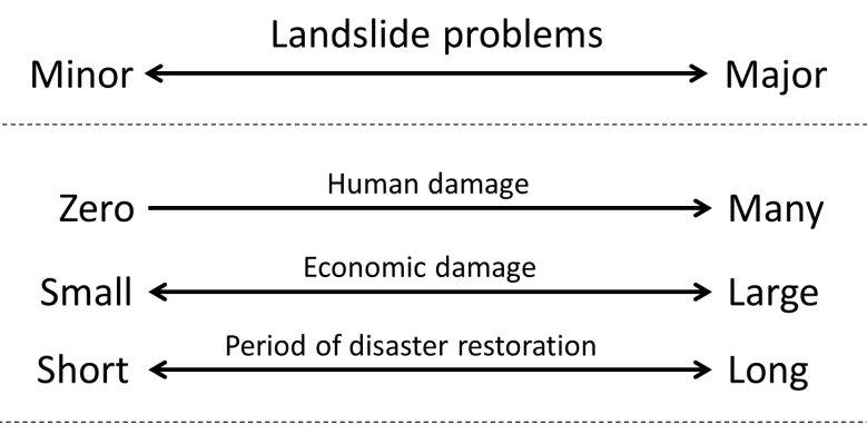 | Figure 1. A concept of major and minor landslide problems |
2.2. Development of Historical Landslide Database in Malay Peninsula
- In order to develop historical landslide database in Malay Peninsula, historical records of landslides have been collected from national reports, technical papers, newspapers and so on related to slope disaster [2-7] in the previous study [10].88 historical landslides have been collected and historical landslide database has been developed. The contents of historical landslide database are location name, city, date, location (a latitude/longitude information), and situation of disaster. However, same events of landslides could not be identified the locations. Locations of 37 landslide events have been identified. All the locations of 37 landslides have been checked by using an aerial photograph and they have been modified from the locations of a stricken area to them of collapsed slopes as shown in Fig. 2.
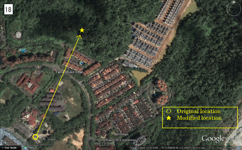 | Figure 2. An example of a modified location of a landslide |
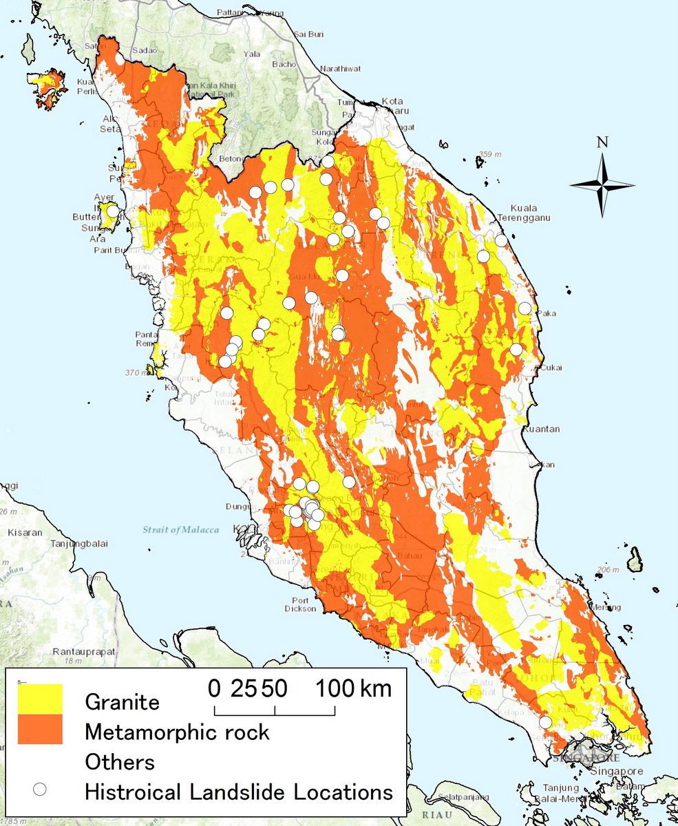 | Figure 3. Locations of historical landslide on a geological map |
3. A Spatial Analysis by Using Landslide Database
- One of factors of landslide is ground properties of slope. Especially, kind of soils and rocks consisting slope is very important to understand slope failure. Figure 3 shows a geological map and the locations of landslides in the developed historical landslide database. The geological map has been reclassified into granite, metamorphic rocks and the others based on geological maps supplied by USM (Universiti Sains Malaysia) and Geological Survey of Japan.Granites and metamorphic rocks have a wide distribution in Malay Peninsula as Fig.3. The figure shows that all the locations of historical landslides have occurred on the categories. Granite has large mineral particles in plutonic rocks and it is generally hard and high density. However, the strength decreases with changing to clay mineral due to the weathering by affected surface water and ground water. In addition, the void between minerals expands and irregular micro-cracks in the rock increase with changing temperature because the component minerals have different coefficient of expansion. Therefore, granite changes to weathered granite by the influence of weather condition. So, strength of granite decreases with progressing the weathering and stability of slope also decreases.On the other hand, metamorphic rock made from igneous, plutonic and sedimentary rocks by a metamorphism caused by heat and pressure. Metamorphic rock contains schistosity in the structure of rock. It is known that metamorphic rock also affect by the weathering [8]. So, strength of metamorphic rock decreases with progressing the weathering and stability of slope also decreases.It seems that tropical rain forest climate in such as Malay Peninsula accelerates the weathering of granites and metamorphic rocks [9]. Therefore, the historical landslide database as shown in Fig.3 indicates that it is important to investigate not only topography and weather but also the weathering of rocks for understanding landslide hazard in Malay Peninsula.
4. Applicability of Landslide Hazard Map in Malay Peninsula
- A landslide hazard map has been proposed in the previous study [11]. The mapping method is very simply and uses regional characteristics of kinds of rocks as shown in Fig.3, rainfall and humidity. In order to confirm the applicability of the mapping method, all the locations in historical landslide database have been plotted on the landslide hazard map. The landslide hazard map and all the locations of historical landslides are shown in Fig. 4. Figure shows that almost all the locations of historical landslides are plotted on the high risk zone. It is necessary to collect more historical landslide events and the related information with high accuracy because the spatial resolution of the map is low. But it seems that the map is available to evaluate landslide hazard.
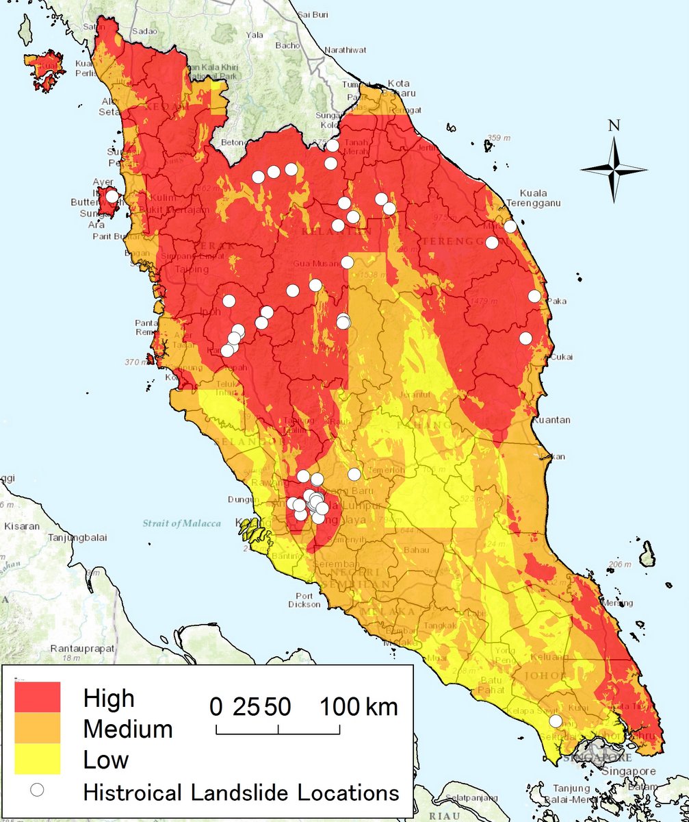 | Figure 4. A landslide hazard map proposed in the previous study and the locations of historical landslide events |
5. Conclusions
- The purpose of this study is to develop a historical land slide database in Malay Peninsula. The database can be available on GIS. The developed historical landslide database has been used with related information to landslide on GIS for investigation of characteristics of landslide in Malay Peninsula.The main conclusions are as follows;(1) A historical landslide database has been developed by collecting from national reports, technical papers, newspapers and so on related to slope disaster. And the database has been upgraded by adding 35 events that are sites at the steel tower of power transmission line and along the road. The historical landslide database can be available to use on GIS (Geographic Information System).(2) It seems that tropical rain forest climate in Malay Peninsula accelerates the weathering of granites and metamorphic rocks. Therefore, the historical landslide database indicates that it is important to investigate not only topography and weather but also the weathering of rocks for understanding landslide hazard in Malay Peninsula.(3) The landslide hazard map proposed in the previous study shows that almost all the locations of historical landslides are plotted on the high risk zone. The proposed map is available to evaluate landslide hazard.
ACKNOWLEDGEMENTS
- This research was supported by Japan Science and Technology Agency (JST)/Japan International Cooperation Agency (JICA), Science and Technology Research Partnership for Sustainable Development (SATREPS), and Ministry of Education, Malaysia (Grant number 203/PJJAUH/6711279). Some of historical landslide data have been supplied by Malaysian Public Works Department. Kind help and advice on this study form Mr. Suhaimi Jamaludin (Malaysian Public Works Department) and Mr. Koay Swee Peng (Universiti Sains Malyasia) are also highly appreciated.
References
| [1] | Asian Disaster Reduction Center, Malaysia Country Report 2008, malaysia+countory+report+2008 (2013/10/29 references). |
| [2] | H. Sasahara, Landslide disater in Malaysia, SABO (Organ of Sabo and landslide technical Center), 2006, 85: 10-17. (in Japanese). |
| [3] | H. Mizuno and N. Osanai, Typhoon Committee Establish: a flash flood and sediment-related disaster forecasting/warning system in a pilot project area in cooperation with DPP component and spread to other area, Technical Note of NILIM (National Institute for Land and Infrastructure Management), 2010, 570: 42. (in Japanese). |
| [4] | A. Hashim, Malaysia Country Profile, Malaysian Meteorological Department, 2010. |
| [5] | EM-DAT: The OFDA/CRED International Disaster Database – www.emdat.be, Université Catholique de Louvain, Brussels (Belgium). |
| [6] | T. A. Ooi and W. H. Ting, Report on Some Major Geotechical Disasters in Malaysia, Proc. International Conference on Geotechnical Engineering for Disaster Mitigation & Rehabilitation, 2005: 151-164. |
| [7] | N. K. Yeong, Rainfall-Induced Landslides in Hulu Kelang Area, Malaysia, Final Year Project, UTAR, 2012. |
| [8] | T. Yamamoto and M. Suzuki, Material Properties and Some Problems of Weathered Sangun Metamorphic Rocks, J. Japanese Geotechnical Society, 2005, 53(6): 19-21. (in Japanese). |
| [9] | B. B. K. Huat, Tropical Residual Soils Engineering, A.A. Balkema Publishers, a member of Taylor & Francis Group plc, 2004: 15. |
| [10] | S. Murakami, T. Nishigaya, Tay Lea Tien, N. Sakai, Habibah Hj Lateh, and Nazirah Azizat, Development of Historical Landslide Database in Malay Peninsula, Proc. 2nd IEEE International Symposium on Telecommunication Technologies (ISTT2014) (submitted). |
| [11] | T. Nishigaya, S. Murakami, and N. Sakai, Hazard Mapping of Slope Failures in Malay Peninsula by Using a Historical Map of Slope Disaster, Proc. 2nd IEEE International Symposium on Telecommunication Technologies (ISTT2014) (submitted). |