Sayantani Nath (Bhadra)
Dept. of Geography, Haringhata Mahavidyalaya, Haringhata, Subarnapur, Nadia
Correspondence to: Sayantani Nath (Bhadra), Dept. of Geography, Haringhata Mahavidyalaya, Haringhata, Subarnapur, Nadia.
| Email: |  |
Copyright © 2015 Scientific & Academic Publishing. All Rights Reserved.
Abstract
Mathurapur-I, Mathurapur-II and Kultali blocks of Sundarban are selected as study area where the people are solely dependent on traditional agriculture mainly in the reclaimed land which is surrounded by embankments to protect the inflow of tidal water by the rivers. In the absence of adequate availability of fresh water from surface water sources ground water provides best alternative in the saline coastal belts. The main obstruction for promoting more area under cultivation in rainless period in the study area is inadequate supply of irrigation water. Irrigation is done mainly by groundwater through shallow tube wells along with surface water from canals, tanks etc. Due to the intrusion of saline tidal waters into the rivers, the surface water irrigation from rivers through river lifting is absent in the study area. Except this, the river water without treatment is not suitable for human consumption. Therefore, ground water plays a vital role in the availability of water in the study area. With a view to utilize ground water resources, especially where surface water is not available in adequate quantity at economic rates, growers prefer to dig wells and construct shallow tube well (STW) near the agricultural fields. Therefore, intensive ground water irrigation became a source for agriculture growth. But rapid depletion, salinization and pollution related problems threaten these regions with sustainable ground water balance. Any strategy for scientific management of ground water resources should involve a combination of supply side and demand side measures depending on the regional setting. In view of the marked difference in stage of ground water in the study area, there is a need to critically analyze the underlying factors responsible for the imbalances in terms of technical and socio-economic considerations. These should also be taken for consideration while formulating any comprehensive water resources management initiatives for the study area. There is urgent need for coordinated efforts by various Governments and non-governmental agencies, social service organizations and the stakeholders for evolving implementable plan for effective management of this precious natural resource.
Keywords:
Traditional agriculture, Reclaimed, Surface water, Ground water, Irrigation, Sustainable ground water
Cite this paper: Sayantani Nath (Bhadra), Stress in Ground Water Utilization and Its Management in Three Selected Blocks of Sundarban, International Journal of Ecosystem, Vol. 5 No. 3A, 2015, pp. 97-108. doi: 10.5923/c.ije.201501.15.
1. Introduction
Groundwater has emerged as the primary democratic water source and poverty reduction tool in rural areas. On account of its near universal availability, dependability and low capital cost, it is the most preferred source of water to meet the requirements of various user sectors in the saline coastal belts especially where surface water is not available in adequate quantity. Ground water has made significant contributions to the growth of any area’s economy and has been an important catalyst for its socio economic development. Its importance as a precious natural resource can be gauged from the fact that domestic water requirements and irrigation requirements are being met from ground water resources. The increasing dependence on ground water as a reliable source of water has resulted indiscriminate development without due regard to the recharging capacities of aquifers and other environmental factors. The unplanned and non-scientific development of ground water resources, mostly driven by individual initiatives has led to an increasing stress on the available resources. The adverse impacts can be observed in the form of long-term decline of ground water levels and de-saturation of aquifer zones. On the other hand, ground water development is still at low-key in spite of the availability of sufficient resources. Sundarban considered as backward area is separated from the mainland by enumerable tidal creeks. The area has a rich natural resource base. But the people here are extremely poor and intensively depend on these natural resources for their livelihood. Mathurapur-I, Mathurapur-II and Kultali blocks of Sundarban are selected as study area where the people are solely dependent on traditional agriculture mainly in the reclaimed land which is surrounded by embankments to protect the inflow of tidal water by the rivers. This agriculture is intensively dependent on rainfall but during rainless periods or the years of deficit rainfall, it is highly dependent on irrigational water. Due to the intrusion of saline tidal waters into the rivers, the surface water irrigation from rivers through river lifting is absent in the study area. Irrigation is done mainly by groundwater through shallow tube wells along with surface water from canals, tanks etc. Except this, the river water without treatment is not suitable for human consumption. These entire together make the stress in ground water utilization in the study area. Therefore, the survival need of the poor people in this area has forced them to degrade the environment. Lack of supplementary or alternative livelihood and income generation, lack of knowledge as well as inadequate infrastructure to use natural resources properly for obtaining maximum economic benefits from them are the main reasons for their poverty. In order to address various issues related to ground water, there is a need to prepare a comprehensive road map with identified strategies for scientific and sustainable management of the available ground water resources in the study area so as to avert the looming water crisis. In addition to addressing the issues of declining water level, the strategies should also focus on the imbalances in ground water development in the study area, reasons thereof and suggesting measures including accelerated development of ground water in areas with low stage of ground water development.
2. Location
The study area (Fig. 1) lies between 21°55′ N to 22°00′ N latitudes and between 88°20′ E to 88°37′ E longitudes and is bounded on the north by the blocks of Mandir Bazar, Joynagar and Canning, on the east by the blocks of Basanti and Gosaba, on the south by Patharpratima block and the Bay of Bengal and on the west by Kulpi block with a total geographical area of about 680.93 sq.km (Census of India 2001). 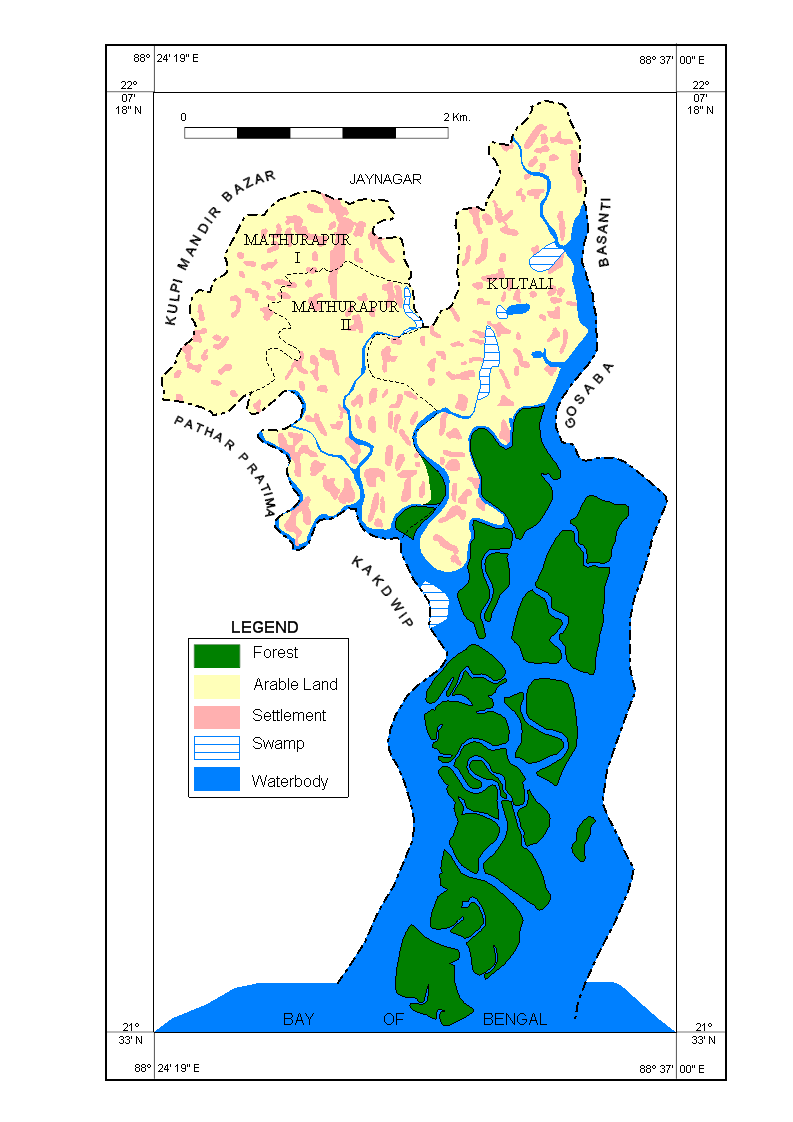 | Figure 1. Study Area Map |
3. Availability of Water
3.1. Surface Water
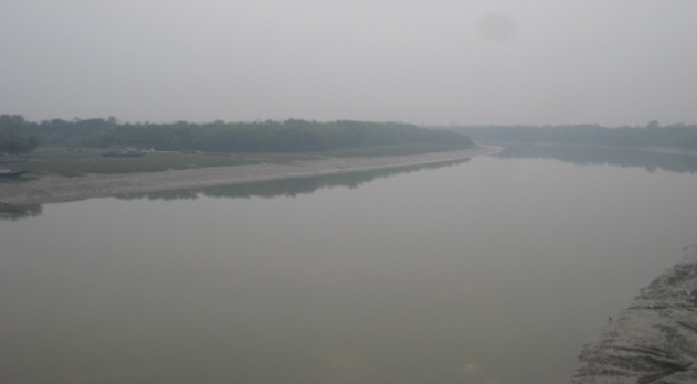
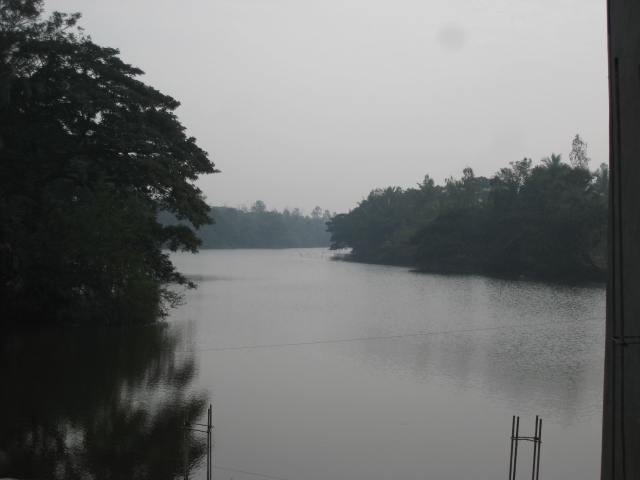
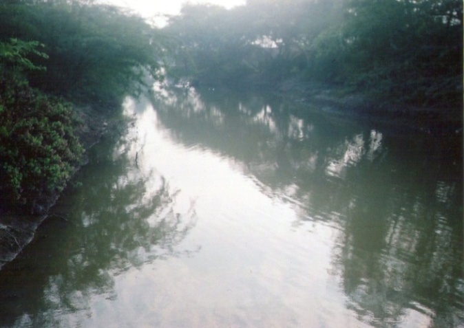
The study area is located in the active part of Ganga delta in Lower Ganga basin. The distributaries Matla (Plate 1), Ajmalmari (Plate 4), Kankalmari, Thakuran (Plate 2), Moni (Plate 3), Piyali, Raidighi (Plate 5), Mridangabhanga (Fig. 2) etc with their distributaries form the main natural drainage in the study area. These distributaries are accompanied with mangrove muddy swamps along their margins. All these rivers open up to the Bay of Bengal. Embankments have been constructed along the banks of these rivers to prevent intrusion of saline tidal waters to adjacent densely populated villages.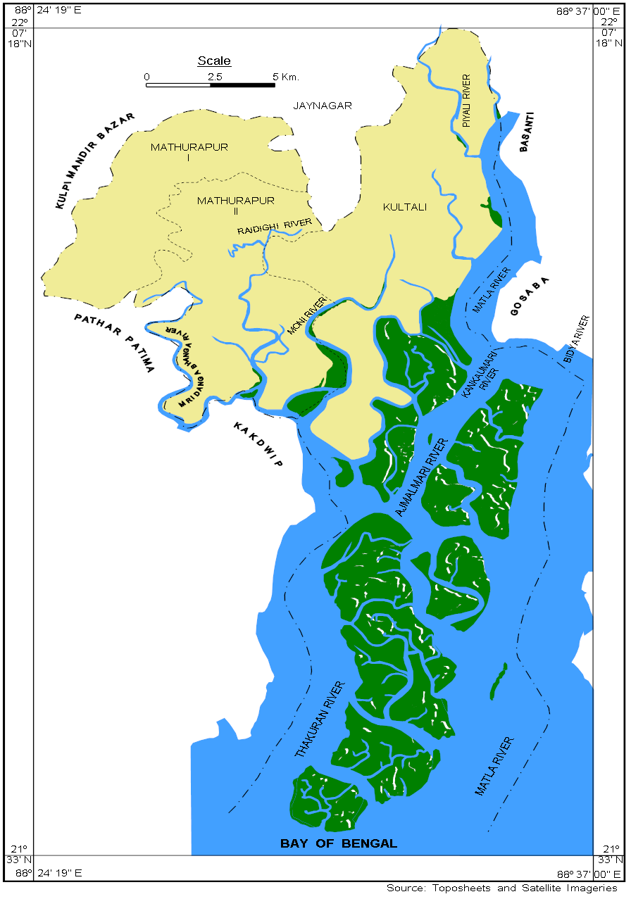 | Figure 2. Drainage Map |
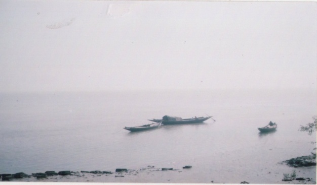 | Plate 1. Matla river (22°0/ N and 88° 37/ E) |
 | Plate 2. Thakuran river (21° 59/ N and 88° 31/ E) |
 | Plate 3. Moni river (22° 0/ N and 88° 30/ E) |
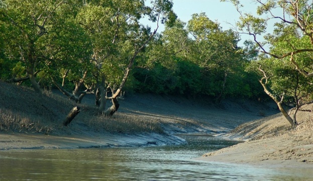 | Plate 4. Ajmalmari river (21°56/ N and 88°35/ E) |
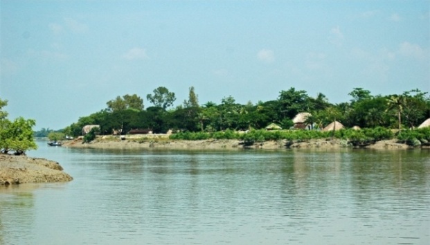 | Plate 5. Raidighi river (21°58/ N and 88°28/ E) |
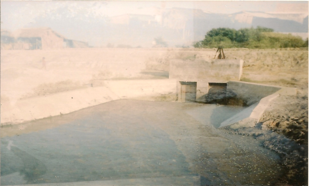
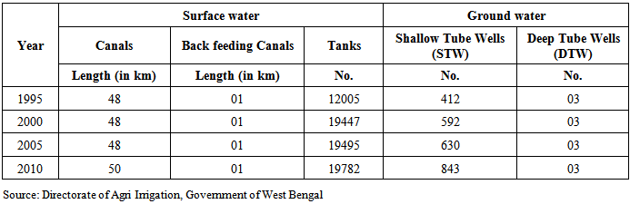
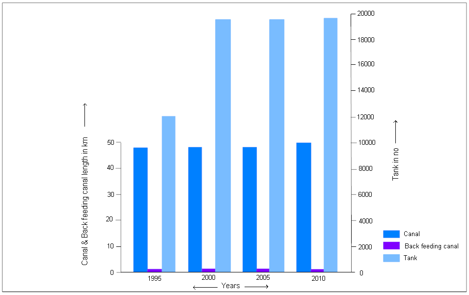
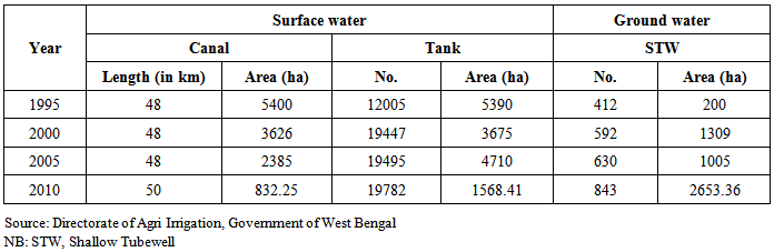
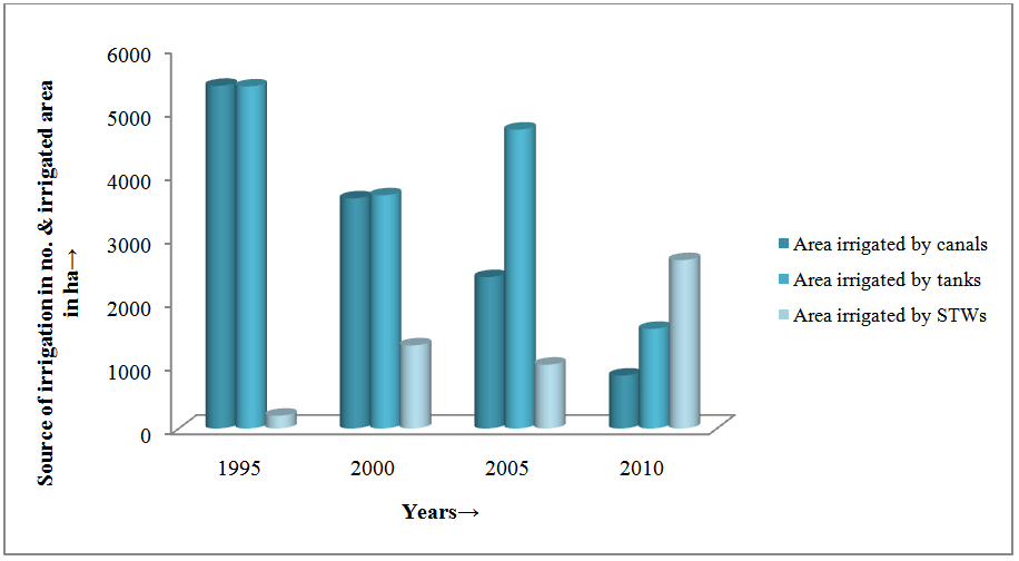
Due to the intrusion of saline tidal waters into the rivers, the use of surface water for agriculture from these rivers through river lift irrigation is absent in the study area. Except this, the river water without treatment is not suitable for human consumption. In the saline affected coastal areas availability of fresh water either for human consumption or for irrigation is constrained due to inadequate number of fresh water tank. Though ground water provides a better alternative in these areas but fresh water aquifer is deep seated. Thus construction of tube well is expensive and out of reach for the rural population.Table 1 represents the fresh water sources available in the study area. Canals and back feeding canals are no longer used as a source of fresh water as they are constructed mainly for additional drainage channel to drain accumulated rainwater or saline water (vide Plate 7). These canals have their connection with tidal creeks through sluice gates.Tanks are the only fresh surface water sources in the area. To meet the increasing demand for fresh water in the study area the number of tanks has substantially increased (64.78%) during the last 16 years (vide Table 1 and Fig. 3). These tanks are mainly used for domestic purposes. There is need for conserving fresh water in the saline coastal belt by digging more tanks where rainwater could be stored for use during dry months. Government initiative in this direction has resulted positive outcome where ponds are dug through NREGS or 100 days work in rural areas. Besides there is need to renovate the existing ponds so that adequate rainwater could be stored. One such existing pond (vide Plate 6) needs urgent renovation.Table 1. Sources of water in the study area (1995-2010)
 |
| |
|
 | Figure 3. Source of surface water in the study area (1995-2010) |
With a view to utilize water resources, especially where surface water is not available in adequate quantity at economic rates, people prefers to excavate canal (vide Plate 7), back feeding canal, tank or pond, shallow tube well (STW) (vide Plate 8) and deep tube well (DTW) for their consumption as well as irrigation. As the expansion of fresh water canal, back feeding canal and number of deep tube well almost remain constant during the 16 years (1995-2010), the source of fresh water resources in the study area are mainly tank and shallow tube well (STW) of which tank is found to be maximum in number compare to other types of fresh water sources (vide Table 1).
3.2. Ground Water
In the absence of adequate availability of fresh water from surface water sources ground water provides best alternative in the saline coastal belts. Subsurface litho logy in the study area indicates that potable ground water is available at a depth beyond 182 m. Thus withdrawal of ground water is very expensive. In spite of the fact that there is substantial increase (more than 100%) in number of small diameter tube wells during the last 16 years (Fig. 4). These tube wells are mainly used to provide safe drinking water for the rural population in the saline coastal belt (vide Plate 8). Constructions of large diameter deep tube wells are restricted in the study area. There are only 3 large diameter deep tube wells in the study area. These deep tube wells are constructed to provide irrigation water in the saline coastal belt at the time of non availability of surface water sources.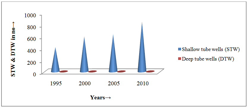 | Figure 4. Source of ground water in the study area (1995-2010) |
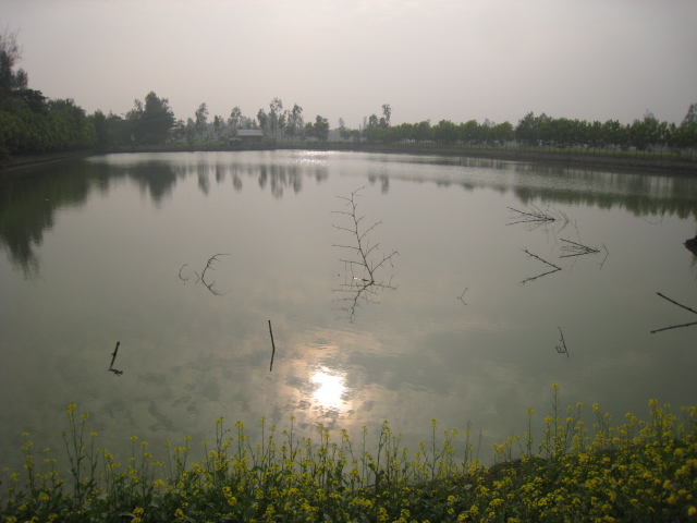 | Plate 6. Tank at Jatar Deul in Mathurapur-II (21°59′ N and 88°29′ E) |
 | Plate 7. Canal (Government) at Jatar Deul in Mathurapur-II (21°59′ N and 88°29′ E) |
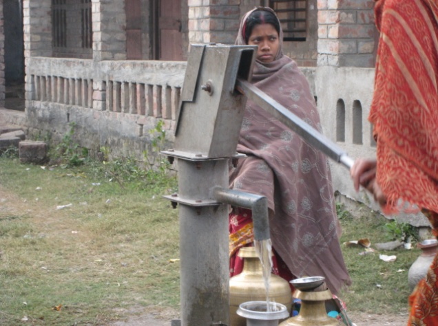 | Plate 8. Shallow tube well as a source of drinking water at Jatar Deul in Mathurapur-II (21°59′ N and 88°29′ E) |
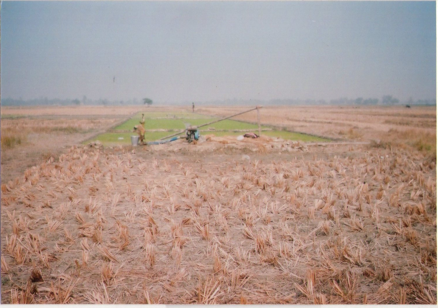
4. Irrigation
The main obstruction for promoting more area under cultivation in rainless period is inadequate supply of irrigation water. It is essential to facilitate supply of back feeding water for bringing more area under more than one crop. For this purpose, implementation of land shaping, excavation and re-excavation of tanks, canals, etc. are also required. Emphasis is to be given on storing of rain water too, for promoting the scope of surface water irrigation.The sources of irrigation in the study area are mainly canal, tank and shallow tube well (STW) of which tank irrigation is found to be in usage rather than the two other types of irrigation.On the basis of the source of irrigation and area irrigated by different sources, during 1995-2010, it is found that nearly 48 km canals were constructed in 1995 and this figure gradually increased to 50 km in 2010. The areas irrigated by canals were 5400 ha, 3626 ha, 2385 ha and only 832.25 ha in 1995, 2000, 2005 and 2010 respectively. The canal irrigation decreased by 5.29% during the last 16 years (1995-2010) (vide Table 2 and Fig. 5).Table 2. Sources of irrigation and irrigated area by different sources
 |
| |
|
 | Figure 5. Area irrigated by different sources |
The canals that are used for irrigation in the study area are presented in Plate 9 and 10.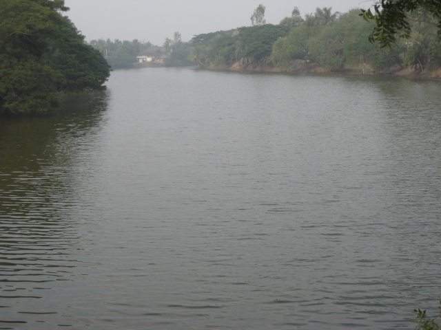 | Plate 9. Canal irrigation at Jatar Deul in Mathurapur-II (21°59′ N and 88°29′ E) |
 | Plate 10. Canal irrigation at Debipur Gurguria in Kultali (21°58′ N and 88°31′ E) |
The number of tank is higher than other types of irrigation. Although many tanks (12005 in 1995 and 19782 in 2010) were excavated during 1995-2010, but the area (3835.85 ha on an average) irrigated by tanks was very limited against the total cultivable land and it reduced by 4.43% during the last 16 years (1995-2010) due to paucity of budgetary allocations in those years and resulted in continued neglect of tank irrigation infrastructure which has equity and sustainability implications. Thus neglected management of tank systems leads to declining storage of surface water. These factors underscore sustainability implications of deteriorating irrigation infrastructure; more in deficit rainfall conditions (vide Table 2 and Fig. 5).Plates 11 and 12 reveal the existing status of tank irrigation in the study area. In the event of non availability of electricity the irrigation pumps are running with the help of diesel oil (vide Plates 12 and 13).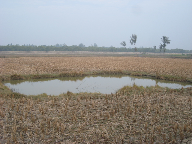 | Plate 11. Tank irrigation at Jatar Deul in Mathurapur-II (21°59′ N and 88°29′ E) |
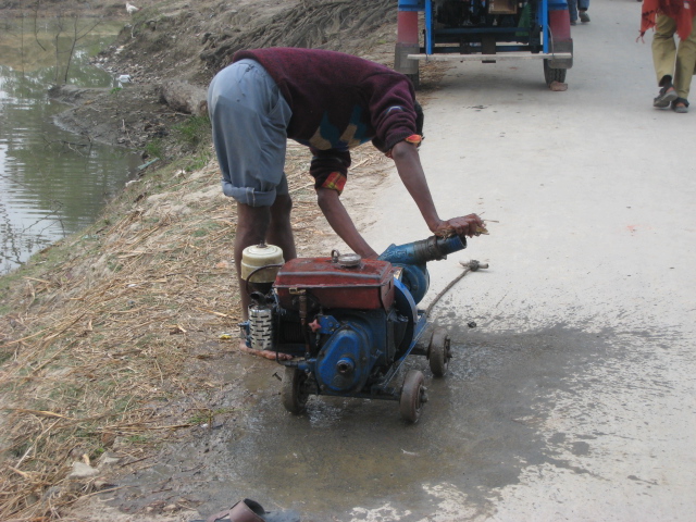 | Plate 12. Tank irrigating pump at Jatar Deul in Mathurapur-II (21°59′ N and 88°29′ E) |
 | Plate 13. Tank irrigation at Paschimgabtala in Kultali (21°58/30′ N and 88°32′ E) |
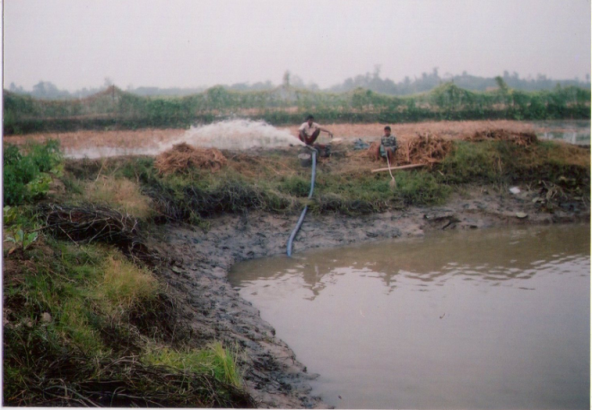
The inadequate supply of irrigation water from surface water sources the farmers are opting for ground water use. Therefore, ground water irrigation would be a source for agricultural growth. But the land under ground water irrigation was still very poor. The average area under this irrigation was only 1291.84 ha throughout 16 years (1995-2010). The area irrigated by STW was less than the areas irrigated by tanks and canals during 1995-2005 as the quality of the shallow ground water is very poor with low hydraulic conductivity. Thus the exploitation of ground water for irrigated agriculture becomes unfeasible (vide Table 2). But in 2010, the area irrigated by ground water was greater than the other types of irrigation (i.e. canal and tank irrigation) (vide Fig 5) because three destructive cyclones (Sider, 2007, Nargis, 2008 and Aila, 2009) forced saline water gushed in through the breaches of the river dykes and mixed with surface water (i.e. with canal and tank waters) in many places which become unsuitable for irrigation. The probable reason for decrease in irrigated areas by the surface water sources during this period. Plate 14 and 15 reveal the existing pattern of ground water irrigation in the study area. The irrigation pump set (vide Plate 16) which is expensive used only by a few big farmers in the study area. As most of the farmers in the study area are small, they cannot afford such kind of pump sets and hence highly dependent on tank irrigation. | Plate 14. Ground water irrigation at Jatar Deul in Mathurapur-II (21°59′ N and 88°29′ E) |
 | Plate 15. Ground water irrigation at Gopalgange in Kultali (21°57′ N and 88°32′ E) |
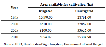
Further analysis of the Table 2 and Fig 5 reveal that there were gradual decrease in surface water irrigation and increase in ground water irrigation. It has also been observed that there is a decrease of 3.38% in irrigated area during the last 16 years. Though modern technology is being practiced slowly in this area but the obtained data indicate that the farming practices still dependent on poor irrigational facilities.As the area under irrigation decreased there was increase in unirrigated areas (Table 3 and Fig 6). Analysis of Table 3 indicates that there was gradual increase of unirrigated area up to 2005. The year 2010 saw a decrease in both irrigated and unirrigated areas. The adverse condition in farming activity in this tract is due to the effect of cyclone during 2009 which swept a major portion of the deltaic tract with surges of tidal wave rendering most of the cultivated land unsuitable for farming practices years together.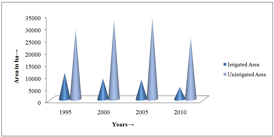 | Figure 6. Irrigated and unirrigated areas |
Table 3. Irrigated and unirrigated areas
 |
| |
|
Besides the no availability of adequate surface water sources, high cost of ground water exploitation, local of knowledge for rainwater harvesting and modern agricultural technology are the main hindrance for agrarian growth and development in the study area. However, modern agricultural technology is being introduced in this saline coastal belt of West Bengal by Bidhan Chandra Krishi Viswavidyalaya. Farmers are encouraged to cultivate superfast rice variety (Kalinga-III) on raised bed to protect them from flooding by saline water during rainy months and it has been reported that Kalinga-III was the most suitable crop in the saline affected areas of Sundarban (Baidya et al 2010).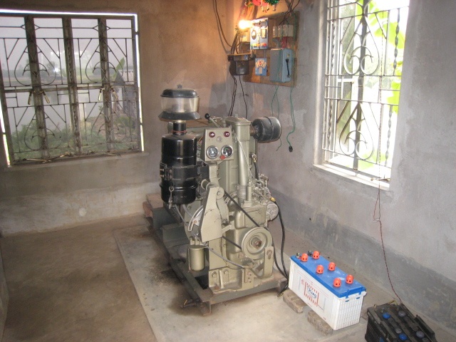 | Plate 16. Irrigation pumpset at Jatar Deul in Mathurapur-II (21°59′ N and 88°29′ E) |
Irrigation is done mainly by groundwater through shallow tube wells along with surface water from canals; tanks etc (vide Table 2). Due to the intrusion of saline tidal waters into the rivers, the surface water irrigation from rivers through river lifting is absent in the study area. Except this, the river water without treatment is not suitable for human consumption. Therefore, ground water plays a vital role in the availability of water in the study area. With a view to utilize ground water resources, especially where surface water is not available in adequate quantity at economic rates, growers prefer to dig wells and construct shallow tube well (STW) near the agricultural fields. Therefore, intensive ground water irrigation became a source for agriculture growth. Rapid depletion, salinization and pollution related problems threaten regions with sustainable ground water balance.
5. Management of Surface Water for Reducing Stress in Ground Water Utilization
Management of ground water resources in the Indian context is an extremely complex proposition as it deals with the interactions between the human society and the physical environment. The highly uneven distribution of ground water availability and its utilization indicates that no single management strategy can be adopted for the country as a whole. On the other hand, each situation demands a solution which takes into account the geomorphic set-up, climatic, hydrologic and hydro geologic settings, ground water availability, water utilization pattern for various sectors and the socio-economic set-up of the region. Any strategy for scientific management of ground water resources involves a combination of A) Supply side measures aimed at increasing extraction of ground water depending on its availability and B) Demand side measures aimed at controlling, protecting and conserving available resources. Various options falling under these categories are described in detail in the following sections.
5.1. Supply Side Measures
As already mentioned, these measures are aimed at increasing the ground water availability, taking the environmental, social and economic factors into consideration. These are also known as ‘structural measures’, which involves scientific development and augmentation of ground water resource. Development of additional ground water resources, through suitable means and augmentation of the ground water resources through artificial recharge and rainwater harvesting fall under this category. For an effective supply-side management, it is imperative to have full knowledge of the hydrologic and hydro geologic controls that govern the yields of aquifers and behavior of ground water levels under abstraction stress. Interaction of surface and ground water and changes in flow and recharge rates are also important considerations in this regard (Jha and Sinha 2009).
5.1.1. Rainwater Harvesting
Rain-water harvesting is a technology which may be used for collecting, storing and conserving rainfall and surface runoff for better management of water. The technology reduces soil erosion in their fields through harvesting runoff water. Furthermore, not only the water and soil conservation benefits cited as resulting from rain water harvesting, but also the possibility of groundwater recharge. The adoption of the rain water harvesting technology has led to changes in cropping patterns such as the introduction of new crops, improved tillage methods and the growing of two or more crops during the same season including winter cropping. Rain water harvesting technology have to a certain extent enhanced cohesiveness of rural social capital in the form of reciprocity, togetherness and co-operation in sharing equipment, labour and ideas. Household labour availability is therefore important, but where it is inadequate, labour groups can fill the gap or the technology can be adopted gradually to reduce labour demands at once. This has led to increased incomes as farmers sell their products, improvement of the farmers’ household food security, diversification in diet and therefore overall improvement of the quality of life among the rain water harvesting adopters. The adoption of the rain water harvesting technology has also enabled the farmers to practice relay cropping on their farms whereby one crop is grown immediately after the other. The rain water harvesting farmers are able to grow at least 2 crops on a rotational basis in one calendar year; it shows that the farmers are intensively utilizing their land. The ability of the technology to increase agricultural productivity among the small farmers, enhancing sustainable agriculture as well as improving household food security. There has been an improvement in the livelihoods of the technology adopters in terms of their standard of living. Furthermore, provision of clean water is an important indicator of the standard of living in rural communities. The fact that some of the technology adopters managed to installs a reliable and safe source of water indicates an improvement in their quality of life. The improvement in housing, sources of energy and agricultural resources has benefits not only to the people but also to the environment.
5.2. Demand Side Measures
Apart from scientific development of available resources, proper ground water resources management requires to focus attention on the judicious utilization of the resources for ensuring their long-term sustainability. Ownership of ground water, need-based allocation pricing of resources, involvement of stake holders in various aspects of planning, execution and monitoring of projects and effective implementation of regulatory measures wherever necessary are the important considerations with regard to demand side ground water management (Jha and Sinha 2009).
6. Conclusions
The study area calls for a holistic approach in evolving suitable management strategies. The emphasis on management needs does not imply that ground water resources in the study area are fully developed. Effective management of available ground water resources requires an integrated approach, combining both supply side and demand side measures. In the study area where the ground water development is sub optimal and there is sufficient scope for future development. Similarly, urgent action is required to augment the ground water in the water stressed areas. However, focus on development activities must now be balanced by management mechanisms to achieve a sustainable utilization of ground water resources. Ground water constitutes the most important source of irrigation water in the study area. The productivity in terms of agricultural output is relatively low in the study area as compared other parts of the state. The ground water development is mostly demand driven; it can be geared up through proper agricultural, credits, subsidy and energy support policies along with creation of suitable markets. In addition, there is a need to concretize methodologies for assessment of development potential of deeper aquifers. There is urgent an need for coordinated efforts from various State Government agencies, non-Governmental and social service organizations, academic institutions and the stakeholders for evolving and implementing suitable ground water management strategies in the study area.
References
| [1] | Baidya, P, Karmakar, S. Khan, D. K. Brahmachari. K. Das, L and Saha, G 2012. Studies on sustainability of superfast rice variety (Kalinga-III) grown under coastal saline climate of West Bengal. Journal of Agrometeorology. 14 (Special Issue). 273-278. |
| [2] | Central Ground Water Board (2002). Master Plan for Artificial Recharge to Groundwater in India. New Delhi. |
| [3] | Central Ground Water Board (2006). Dynamic Ground Water Resources of India. New Delhi. |
| [4] | Das, S. (2006). Groundwater overexploitation and importance of water management in India – Vision 2025. Tenth IGC foundation lecture. The Indian Geological Congress. Roorkee. |
| [5] | Ground water governance in the Indo-Gangetic and Yellow River Basins - Realities and Challenges. Edited Vol. Aditi Mukherjee et.al. IAH selected papers. |
| [6] | Jha B.M. (2007). Management of Ground water resources for Ensuring Food Security in India. National Ground Water Congress. New Delhi. |
| [7] | Jha. B.M., Sinha S.K. (2009). Towards Better Management of Ground Water Resources in India. Central Ground Water Board. Bhujal Bhawan. CGO Complex. NH IV. Faridabad. Haryana. India. |
| [8] | Llamas, M. Ramon, Mukherjee, Aditi and Shah, Tushaar (2006). Guest editors' preface on the theme issue "Social and economic aspects of groundwater governance. Hydrogeology Journal. Vol. 14(3). pp. 269-274. |
| [9] | Ministry of Water Resources (2002). National Water Policy. New Delhi. |
| [10] | Minor Irrigation Division (1993). Report on Census of Minor Irrigation Schemes – 1986-87. Ministry of Water Resources. New Delhi. |
| [11] | Minor Irrigation Division (2001). Report on Census of Minor Irrigation Schemes – 1993-94. Ministry of Water Resources. New Delhi. |
| [12] | Minor Irrigation Division (2005) Report on 3rd Census of Minor Irrigation Schemes – 2000-01. Ministry of Water Resources. New Delhi. |
| [13] | National Institute of Hydrology. Roorkee and Central Ground Water Board (2006). An operational model for groundwater pumping at Palla Well Fields. NCT Delhi – Project Report. |
| [14] | Planning Commission (under publication). Ground water ownership in the country. Draft report of the Expert Group. |
| [15] | Romani, Saleem (2006). Groundwater Management – Emerging challenges. Groundwater Governance – Ownership of Groundwater and its Pricing. Proceedings of the 12th National Symposium on Hydrology. November 14-15, 2006. New Delhi. |
| [16] | Shah, Tushaar and Shilp Verma (2007). Real-time Co-management of Electricity and Groundwater: An assessment of Gujarat's Pioneering Jyotigram Scheme - Discussion paper. International Water Management Institute (IWMI). |
 Abstract
 Reference
 Full-Text PDF
 Full-text HTML