-
Paper Information
- Next Paper
- Previous Paper
- Paper Submission
-
Journal Information
- About This Journal
- Editorial Board
- Current Issue
- Archive
- Author Guidelines
- Contact Us
International Journal of Ecosystem
p-ISSN: 2165-8889 e-ISSN: 2165-8919
2015; 5(3A): 86-88
doi:10.5923/c.ije.201501.12
Groundwater towards Sustainable Agriculture – A Global Challenge
 Abstract
 Reference
 Full-Text PDF
 Full-text HTML
Mahuya Patra (Roy)
Assistant Professor in Chemistry, Ramananda College, Bishnupur, Bankura
Correspondence to: Mahuya Patra (Roy), Assistant Professor in Chemistry, Ramananda College, Bishnupur, Bankura.
| Email: |  |
Copyright © 2015 Scientific & Academic Publishing. All Rights Reserved.
Worldwide, the utilization of groundwater and its planned use has been an important factor in uplifting productivity of agriculture and ensuring predictability in outputs. Water is essential to bring forth the potential of the land and to enable improved varieties of both plants and animals to make full use of other yield-enhancing production factors. By enhancing productivity, sustainable water management (especially when combined with adequate soil husbandry) helps to ensure better production both for direct consumption and for commercial disposal, so enhancing the generation of necessary economic surpluses for uplifting rural economies. Since the 1960s, global food production has at least kept pace with world population growth, providing more food per capita at generally declining prices, but at a cost to water resources. At the close of the 20th century, agriculture used a global average of 70% of all water withdrawals, and FAO estimates that global abstractions for irrigation will grow by some 14% by 2030. While this is a much slower rate than experienced in the 1990's, water scarcity stress is projected to grow locally and, in some cases, regionally, constraining local food production.
Keywords: Groundwater, Sustainability, Arsenic Contamination
Cite this paper: Mahuya Patra (Roy), Groundwater towards Sustainable Agriculture – A Global Challenge, International Journal of Ecosystem, Vol. 5 No. 3A, 2015, pp. 86-88. doi: 10.5923/c.ije.201501.12.
Article Outline
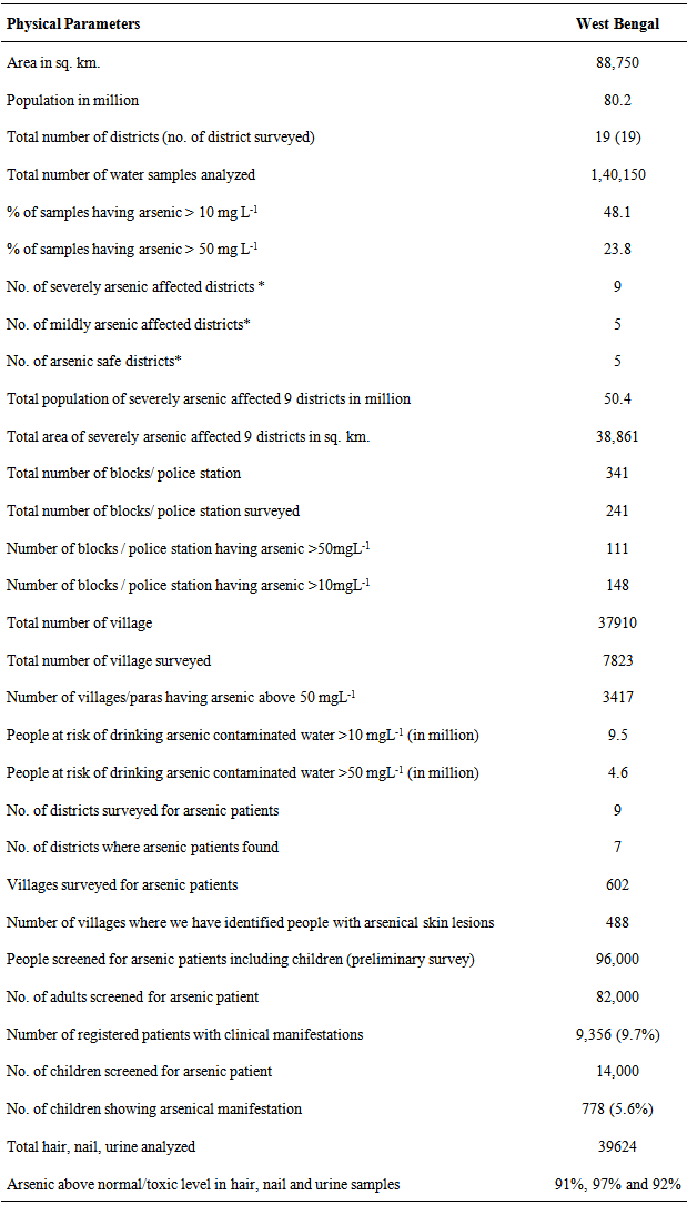
- Groundwater is the water situated beneath Earth’s surface in soil pore space and in the fractures of rock formation. Groundwater is recharged from and eventually flows to the surface naturally; natural discharge often occurs at spring and seeds and can form oases or wetlands. It is the ultimatum for living of many rural and agricultural regions and their associated cultures and population around the globe and a cornerstone of global food production. Ground water constitutes nearly half the world’s drinking water and much of the world’s irrigated water supply.This groundwater is also often used for agriculture, municipal and industrial use by constructing and operating extraction well. Population growth, over exploitation, salinization, non points source pollution from agricultural activities impacts to ground water quality and quality conflicts to at the urban-rural interface have reached global dimensions and threaten the health and livelihood of plants overall on agriculture.It is well known that agriculture is the largest user of ground water using a global average of 70% of all surface water supplies. Sustainable agriculture is one of the greatest challenges. Sustainability implies that agriculture not only provide a assured food supply, but that should be environmental, socio economic and also from the standpoint of human health.Improved agricultural water using irrigated and rainfed agriculture will play a key role in coping with the expected water scarcity stress. Improving water use or water productivity is often understood in terms of obtaining as much crop as possible per volume of water. Money-wise farmers may prefer to target a maximum income per unit of water. Thus in a broader sense increasing productivity in agriculture can result in more benefit for every unit of water withdrawn from natural water sources.General mills is a member of sustainable agriculture initiative (SAI) platform, an organisation founded by companies in the food industry to support the development of sustainable agriculture practice. Agroclimatic Zones of West BengalRO-CLIMATIC ZONES OF WEST BENGALHill Zone (2.428 lakh ha)Terai Zone (2.149 lakh ha)Old Alluvial Zone (17.537 lakh haNew Alluvial Zone (15.304 lakh ha)Red and Laterite Zone (24.842 lakh haCoastal and Saline Zone (14.569 lakh haSummary of Groundwater arsenic contamination situation in West Bengal Location and demography West Bengal is one of the 29 states in India. It extends to the east longitude 85°50’E and 89°50’E and north latitude 21°10’N and 27°38’N. The area of West Bengal is 89193 sq. km having a population of about 80.1 million.Regional Geological setting The State of West Bengal can be divided into four physiographic parts:1. Districts of Darjeeling, Jalpaiguri and Koochbihar in the 2. Himalayan Region.3. District of Purulia and Western part of the districts of Bardhaman, Medinipur, Birbhum and northern part of Bankura occupy the eastern fringe of Chotanagpur Plateau.4. Sundarban area of the South 24 Parganas and small part of North 24 Parganas form the Deltaic zone.5. Remaining areas of the State being plains.150-250m thick granular zone occurring as alluvial fans in the extreme northern part of West Bengal acts as the recharge zone for the unconfined aquifers with high permeability. This zone receives on an average 3000mm of rainfall annually. This granular zone gets separated in most of the areas by 2 to 10 m thick clay layers within a depth of about 300m where confined groundwater occurs. These aquifers at depth to the south of the fan zone are hydraulically connected to the recharge zone and contain groundwater mildly affected by arsenic. The recent flood plain deposits of Malda district, however, recorded high concentration of groundwater arsenic.The subsurface geological picture of the southern part of West Bengal to the east of the Achaeans shield area is nearly similar to its northern counterpart except the absence of cobbles and pebbles in the sequence and the Pleistocene sediments covering almost one-half of the area to the east of the shield area. Eastward Holocene deltaic sediments that by nature are characterized by frequent change in facieses from sand to clay and vice-versa at short distances both laterally and vertically follow it. At the delta head located in Murshidabad and Nadia districts, 150-250m thick granular zone containing groundwater with high concentration of arsenic under unconfined condition occurs. It forms the recharge zone for the deeper aquifers down south. Like the Northern part, here also this thick granular zone gets separated by several clay layers, the thickness of which gradually increases southward. Beside, a clay layer appears at the top of the sequence with thickness gradually increasing southward from 2 to 30m precluding direct rainfall recharge to the group of aquifers below the top clay. These aquifers constitute the confined aquifer system receiving water from the recharge area to the north as well as to the west formed by the weathered sections within the crystalline rocks in the shield area.In and around Kolkata beside the top clay layer, another 20-30m thick clay layers occurs at around 150m depth, the thickness of which increases to 50-60m further south. It is followed by alternating sequence of sand and clay layers down to a depth of about 300m.In the delta and flood plains due to attenuation of intervening clay layers, the group of aquifers at depth gets interconnected at some places giving avenues for polluted groundwater to travel at deeper depths.Overall contamination situation in West Bengal According to the latest available data, A.D.O department of west bengal hav analyzed 1,40,150 hand tubewell water samples for arsenic in all 19 districts covering 241 of 341 total blocks from West Bengal India. Table 1 shows an overview of arsenic contamination situation of West Bengal upto December 2005.
|
ACKNOWLEDGEMENTS
- I am thankful to the Agriculture Development Office, Purulia, Government of West Bengal regarding the statistics given above.