Sakila Haque
Department of Geography, Muzaffar Ahmed Mahavidyalaya, West Bengal, India
Correspondence to: Sakila Haque, Department of Geography, Muzaffar Ahmed Mahavidyalaya, West Bengal, India.
| Email: |  |
Copyright © 2015 Scientific & Academic Publishing. All Rights Reserved.
Abstract
Irrigation, simply, refers to the artificial way of providing water to plants. It is a very important non-physical input in modern agriculture as the crop production of an area largely depends on the existing irrigation facility. Its urgency needs no emphasis for having a stable and successful agriculture in an area like the Murshidabad District where rainfall is seasonally concentrated and unreliable. The Murshidabad District has secured a good position in agricultural production in West Bengal during the past two decades and its irrigation has also increased but not equally at blocklevel. This paper attempts to find out the spatial pattern of change in irrigation intensity and also the relation between irrigation intensity and cropping intensity in Murshidabad District at C.D.Blocklevel for the years of 1994-95 and 2010-11 and the relation between the changes in cropping intensity and irrigation intensity in this period. Karl Pearson’s Product Moment Correlation Coefficient method has been adopted to measure the relationship between irrigation intensity and cropping intensity. This paper also attempts to make acomparative study of percentage of area under groundwater irrigation in the C.D. Blocks of the district in 1994-95 and 2010-11.The study also reveals acomparative study of net availability and gross draft of ground water in the 26 C.D. Blocks of the district and to identify the vulnerable C.D. Blocks.
Keywords:
Irrigation intensity, Cropping intensity, Groundwater
Cite this paper: Sakila Haque, Impact of Irrigation on Cropping Intensity and Potentiality of Groundwater in Murshidabad District of West Bengal, India, International Journal of Ecosystem, Vol. 5 No. 3A, 2015, pp. 55-64. doi: 10.5923/c.ije.201501.08.
1. Introduction
The economy of Murshidabad District is solely supported by agriculture. As the population is growing very fast the farmers have adopted the water intensive monoculture, leaving behind the traditional multiple cropping patterns. “The real breakthrough in this regard, however, came after the introduction of Green Revolution technology in mid-sixties. High yielding varieties of seeds and chemical fertilizers were the chief ingredients in this technology. The use of inputs pre- required the development of assured irrigation” (Singh, 1977). This water intensive monoculture has created a huge pressure on ground water as more than 70% of the net irrigated area Murshidabad District is ground water irrigation fed. Ground water occurs in a thick zone of saturation in the alluvium deposited by the river system, under unconfined conditions particularly in the Baghri Tract and partly unconfined and partly semi-confined aquifer condition in the Rarh Tract. “The sand and gravel horizons of different textures constitute the main aquifers and occur down to 90-350 mbglin the eastern part and 150 mbgl in the western part of the district”. (Ghosh, 2007)
2. The Study Area
Murshidabad District, lying at the apex of the Gangetic delta, extends from 23⁰45'30" North to 24⁰52'30" North latitudes and 87⁰57'30" East to 88⁰46'15" East longitudes covering a total geographical area of 531611 hectares. The District is bounded by Malda District and Bangladesh on the north and by Bangladesh on the east, by Barddhaman and Nadia Districts on the south and by Birbhum District and Jharkhand on the west. The total population of the district is 7102430 persons out of which 5,697,224 persons i.e. 80.22% are rural population (Census of India, 2011). It consists of 26 C.D. Blocks with 2210 villages. There are three Agro-Ecological Situations (ASE) in Murshidabad District – ASE-I (old alluvial zone), ASE-II (lateritic light zone) and ASE-III (new alluvium zone).
3. Objectives
The main objectives of the study are as follow1. To find out the relationship between irrigation intensity and cropping intensity of the 26 C. D. Blocks in Murshidabad district during the period 1994-95 and 2010-11.2. To make a comparative study of percentage of area under groundwater irrigation in the C.D. Blocks of the district for the cropping years 1994-95 and 2010-11.3. To make a comparative study of net availability and gross draft of ground water in the 26 C.D. Blocks of the district and to identify the vulnerable C. D. Blocks.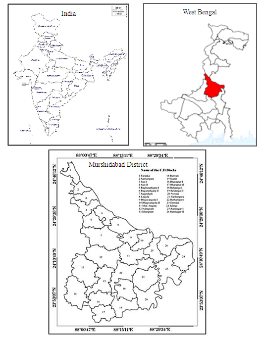 | Figure 1. Location Map of the Study Area |
4. Database and Methodology
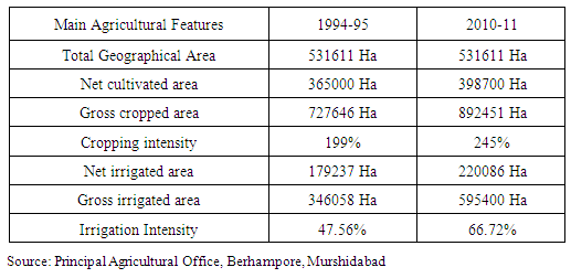
Data Sources: The present study is based on the secondary data which have been collected from the Principal Agricultural Office of Murshidabad District, Berhampore, Government of West Bengal, the SWID, Berhampore, Murshidabad District, the Agri. Mech. Department of Murshidabad District, Berhampore, Government of West Bengal and the District Library of Murshidabad, Murshidabad District.Methods and Techniques: The collected data have been presented statistically as well as cartographically. The following formulae are used here:1. C.D. Blockwise Cropping Intensity has been calculated for the years 1994-95 and 2010-11 using the following formula (after Bureau of Applied Economics and Statistics, Government of West Bengal) Cropping Intensity= (Gross cropped Area/Net Cropped Area) ×1002. C.D. Blockwise Irrigation Intensity has been calculated for the years 1994-95 and 2010-11 using the following formula(after Bureau of Applied Economics and Statistics, Government of West Bengal) Irrigation Intensity= (Gross Irrigated Area/Gross Cropped Area) ×1003. The relationship between Irrigation Intensity and Cropping Intensity at C.D. Blocklevel for the years 1994-95 and 2010-11 has been shown using the Coefficient of Correlation (Karl Pearson, 1896) formula.
5. Results
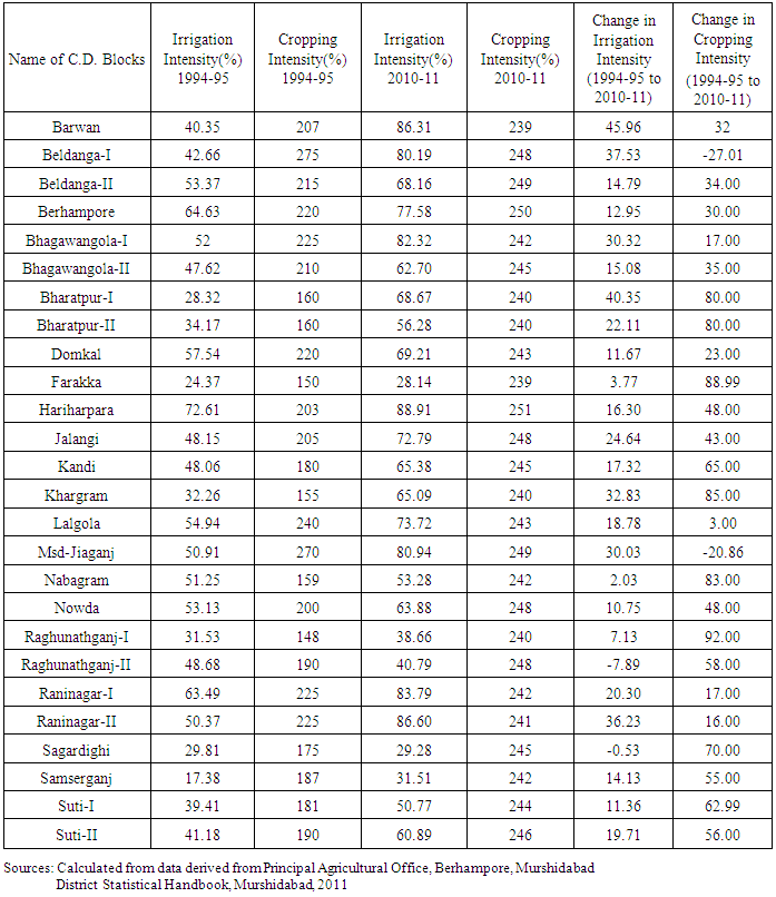
Table 1. Irrigation Intensity and Cropping Intensity in 26 C.D.Blocks, Murshidabad District (1994-95 and 2010-11)
 |
| |
|
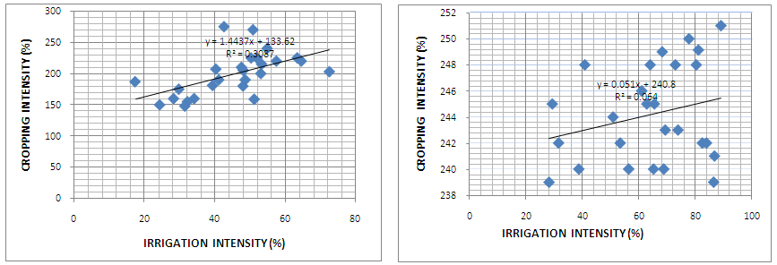 | Graph-1 & Graph-2. C.D.Blockwise Relationship between Irrigation Intensity and Cropping Intensity in Murshidabad District (Graph-1 for 1994-95 and Graph -2 for2010-11) |
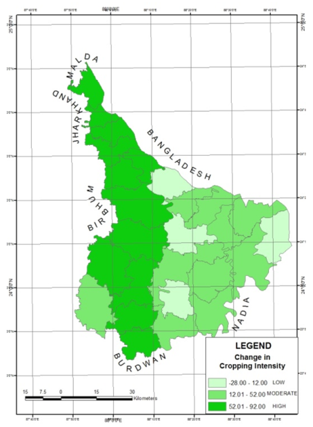 | Figure 2. C.D.Blockwise Change in Cropping Intensity from 1994-95 to 2010-11 |
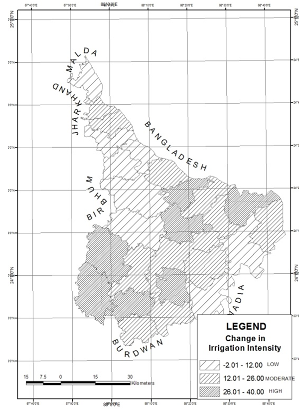 | Figure 3. C.D.Blockwise Change in Irrigation Intensity from 1994-95 to 2010-11 |
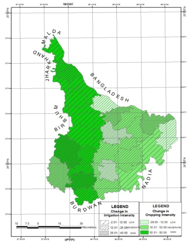 | Figure 4. C.D.Blockwise Relationship between Changes in Irrigation Intensity and Cropping Intensity from 1994-95 to 2010-11 |
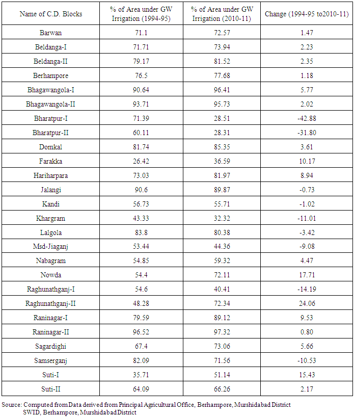
Table 2. Percentage of Area under groundwater Irrigation in 26 C.D.Blocks, Murshidabad District (1994-95 and 2010-11)
 |
| |
|
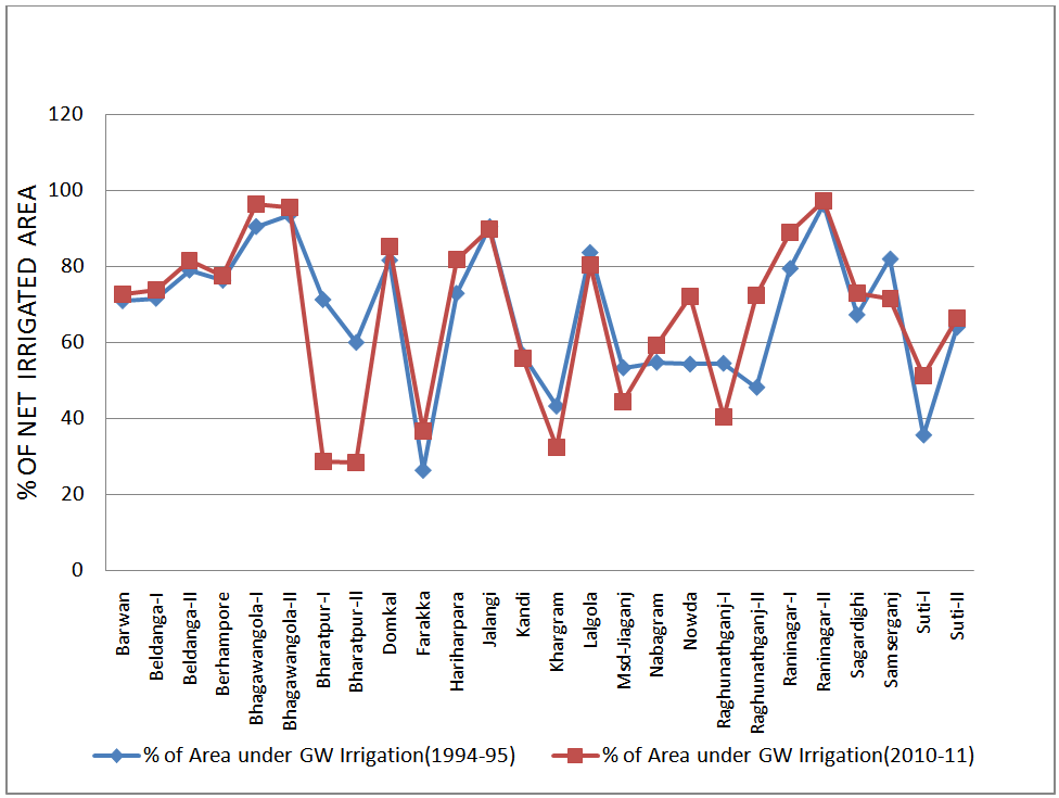 | Graph 3. Percentage of Net Irrigated Area under Ground Water Irrigation in 26 C.D.Blocks, Murshidabad District (1994-95 and 2010-11) |
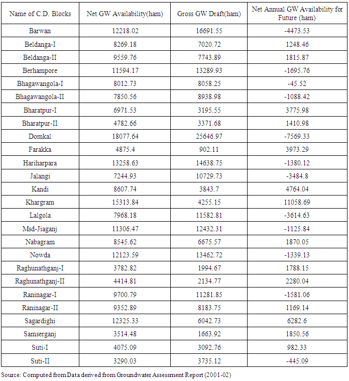
Table 3. Net Ground Water Availability and Gross Ground Water Draft of 26 C.D. Blocks, Murshidabad District
 |
| |
|
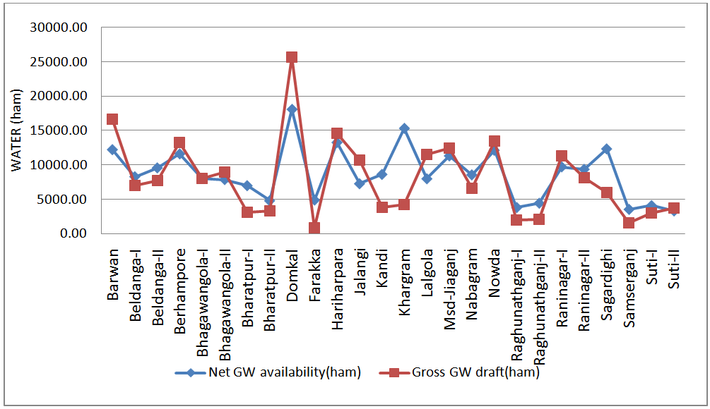 | Graph 4. C.D.Blockwise Relation between Net Ground Water Availability and Gross Ground Water Draft in Murshidabad District |
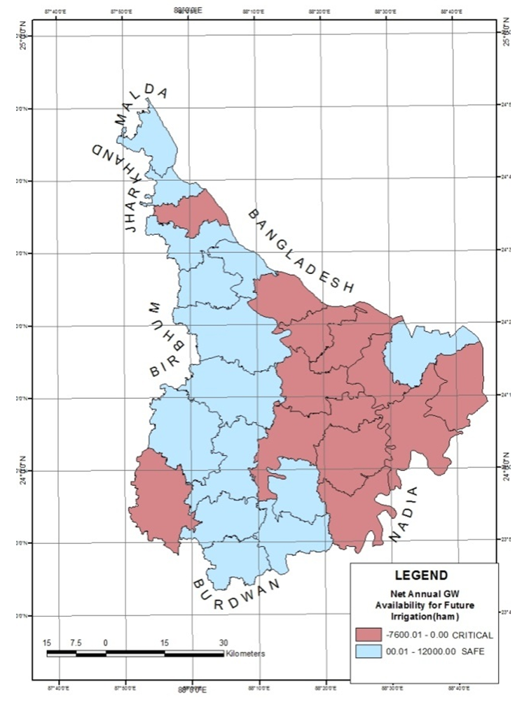 | Figure 5. Net Annual Ground Water Availability for Future Irrigation |
6. Findings
1. The dependency of cropping intensity on irrigation intensity has decreased from 1994-95 to2010-11 as the value of r became 0.56 in 1994-95 (Graph-1) to 0.25 in 2010-11 (Graph-2). It indicates that the relation between irrigation intensity and cropping intensity remained positive but it became weaker i.e. the dependency of cropping intensity on irrigation intensity is reduced in Murshidabad District from 1994-95 to 2010-11.2. The maps of Murshidabad District on change in irrigation intensity and change in cropping intensity from 1994-95 to 2010-11 (Fig.-1 & 2) and also the superimposed map (Fig.-3) are showing that only two C.D.Blocks viz. Barwan and Bharatpur-I have experienced high changes in bothirrigation intensity and cropping intensity, whereas in others C.D.Blocks of the RarhTract, the cropping intensity has increased moderate to high but irrigation intensity has increased low to moderate and maximum C.D.Blocks of the Baghri Tract have experienced moderate to low increase in cropping intensity but high to moderate increase in irrigation intensity.3. In case of percentage of irrigated area under ground water irrigation , in the C.D.Blocks of Bharatpur-I and II, Kandi, Khargram, Raghunathganj-I, Samserganj, Jalangi, Lalgola, Msd-Jiaganj the percentage has been decreased whereas in the other C.D.Blocks of the district the percentage has been increased. Maximum decrease has been found in the Bharatpur I (42.88%) and II(31.80%) C.D.Blocks whereas maximum increase has been found in the Raghunathganj II(24.06%) C.D.Block (Graph-2).4. The gross draft of ground water is more than net availability in the C.D. Blocks of the Baghri Tract of the district except the Bhagwangola-I, Raninagar II, Beldanga I and II C.D. blocks whereas the gross draft is less in the C.D.Blocks of the Rarh Tract except the Suti-II and Barwan C.D.Blocks of the district (Graph-3).5. Maximum of the C.D.Blocks in the eastern side of the Bhagirathi River, except Jalangi C.D.Block, are in critical situation on the basis of net annual availability of ground water for future use as compared to the C.D.Blocks, except Bharatpur-II and Suti-II C.D.Blocks, in the western side of the Bhagirathi River which are relatively in safe situation (Fig.-4). Here the groundwater recharge factor is not taken into consideration.
7. Conclusions
The study reveals that the cropping intensity in Murshidabad District is not solely dependent on the irrigation but on the other factors also. With the increase in the irrigation the ground water abstraction has become very high resulting the groundwater depletion as well as unavailability of groundwater in Murshidabad District. “For last 10 years the ground water level is declining. The rate of decline is 0.01 to 0.4 meters/ year and rising trend is 0.01 to 0.18 m/year “(Ghosh, 2007). The risk of toxic metal contamination has also been increased. “22 out of 26 C.D. Blocks have arsenic concentration” (Samadder and Subbarao, 2007) which make the district “one of the worst affected areas in the world by arsenicosis”. But to cope with the rapid population growth the agriculture should be developed adopting the ways like - more emphasis on irrigation through surface water use, construction of more water reservoirs, conservation of the existing wetlands and water bodies, impeding surface run-off, rainwater harvesting and also multi-crop farming. The effective management of available ground water resources requires an integrated approach, combining both supply side and demand side measures .“However, focus on development activities must now be balanced by management mechanisms to achieve a sustainable utilization of ground water resources as it constitutes the most important source of irrigation water in the Gangetic plains…” (Jha, B.M, 2009).
References
| [1] | “A Brief Account on Departmental Activities for Development of Agriculture”, Office of the Principal Agricultural Officer, Murshidabad, Berhampore,1995. |
| [2] | District Census HandBook: Murshidabad (2001). Directorate of Census operation, West Bengal, Part XII A& B Series. |
| [3] | Distrct Statistical Handbook: Murshidabad (2011), Bureau of Applied Economics & Statistics, Government of West Bengal |
| [4] | Evaluation Wing, Directorate of Agriculture, Government of West Bengal,2010-11. |
| [5] | Ghosh, A. K. (2007), ‘Groundwater Information Booklet, District Murshidabad (Arsenic affected area) West Bengal’, Central Groundwater Board, Eastern Region, Kolkata, Government of India, Ministry of Water Resource. |
| [6] | Samaddar, S.R. and Subbarao, C. (2007); “GIS Approach of Delineation and Risk Assessment of Areas Affected by Arsenic Pollution in Drinking Water.” DOI: 10.1061/ (ASCE) 0733-9372(2007) 133:7(742).pp-1. |
| [7] | Singh, B.(1977), “Landuse: Its Efficiency, Stages and Optimum Use: Problems and Scope”, The National Geographical Journal of India, Vol. 23, pp.61-77. |
| [8] | Swadesh Pal and Osondu C. Akoma (2009): “Water Scarcity in Wetland Area within Kandi Block of West Bengal: A Hydro-Ecological Assessment.”; Ethiopian journal of Environmental studies and Management, vol. 2 no. 3. pp:1-12. |
| [9] | Bhalla, G.S, (2008); “Indian Agriculture Since Independence” National Book Trust, India, New Delhi, pp.133. |
| [10] | Jha, B.M., Sinha, S.K. (2009): 'Towards Better Management of Ground Water Resources in India.' in BhuJal News, vol.24, no.4, pp.1-20. |
 Abstract
 Reference
 Full-Text PDF
 Full-text HTML